search
Portugal regions map
Map of Portugal regions. Portugal regions map (Southern Europe - Europe) to print. Portugal regions map (Southern Europe - Europe) to download. Historically, by the end of the 18th century there were no regional forms of government, or regional identities; the concept of natural inner borders did not exist and the provinces did not have territorial unity. In November 1998, eight regions were officially identified by Decree Law 18/98, which resulted from an accord between the Socialist Party (PS) and the Portuguese Communist Party (PCP) in July 1997 as its shown in Portugal regions map. Trying to find an effective form of regional division, the compromise resulted in the PCP and The Greens (PEV) accepting the Entre Douro e Minho region, and the PS removing their demands for a division of the Alto and Baixo Alentejo region's definition.
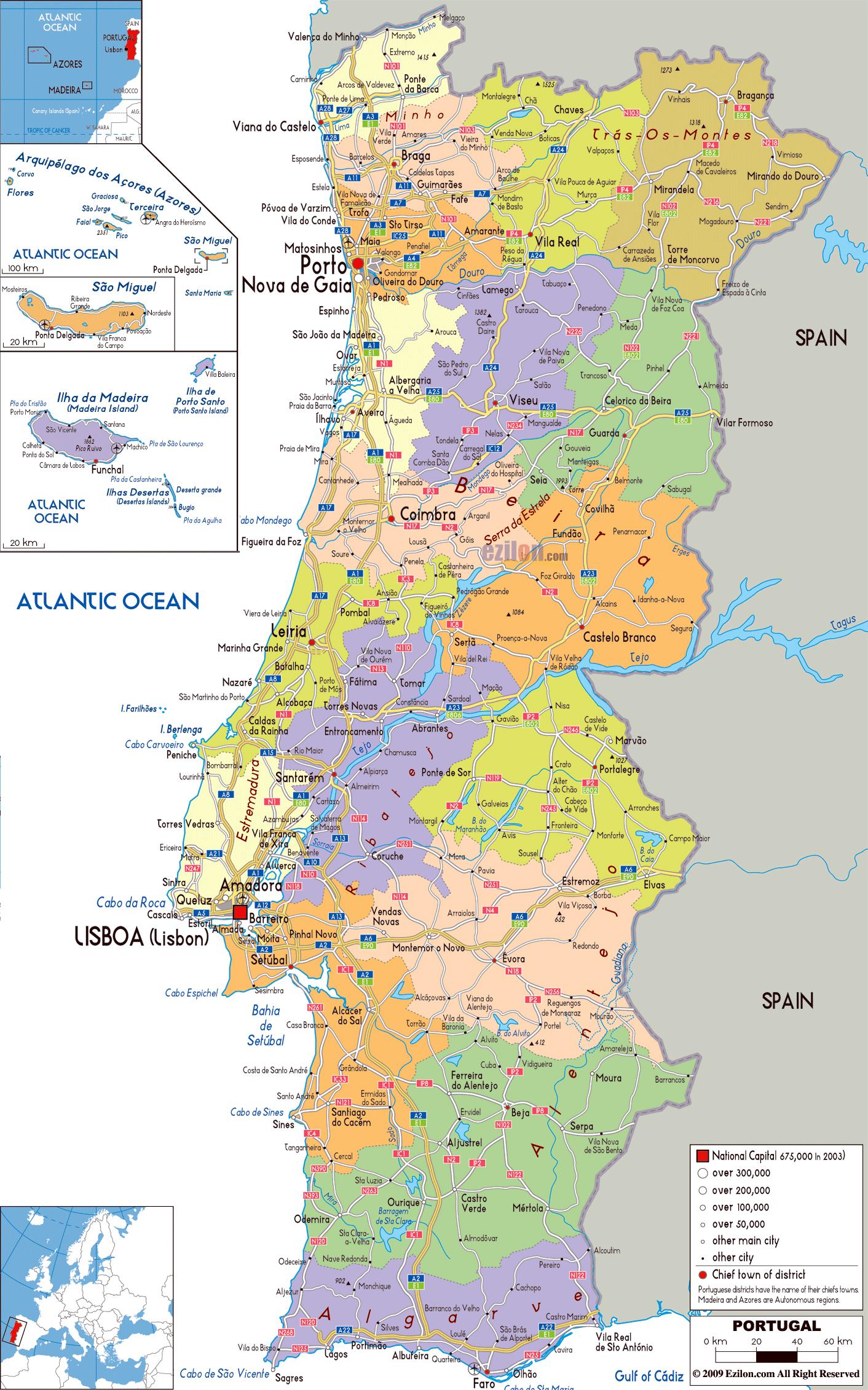
The new territorial map of eight regions would include minor revisions to the borders (the southern border of the Douro, Alto Ribeatejo and Alta Extremadura as you can see in Portugal regions map), resulting in a consultation with respective municipal authorities. The new regional map was later referred jokingly as theMapa da T.S.F., because many of the political decision-makers made their decisions on the plan after listening to public comments from the transmissions of T.S.F. Rádio Notícias. This transmission showed that, although the idea of regions was acceptable to the public, there was less consensus on their limits, or even outright hostility. Party politics influenced municipal decisions to accept the proposal or assume positions that were not appreciated by the populations. The final map was neither an amalgamation of the districts or provinces, nor a dismemberment of the Áreas de Intervenção das Comissões de Coordenação Regional (English: Intervention Areas of the Regional Coordination Commissions), but there was confusion and disinformation, resulting in local unwillingness to accept regionalization in general.
Since 1978, Portugal conceded political autonomy to its North Atlantic archipelagos (Madeira and Azores) due to their distance, isolation, geographical context and socio-economic circumstances. The regional autonomies have their own organic laws, regional governments and administration, overseen by a Regional Government (Portuguese: Governo Regional), constituted by a Regional Presidency (Portuguese: Presidente do Governo Regional) and Cabinet comprising several Regional Secretaries (Portuguese: Secretários Regionais) as its mentioned in Portugal regions map. The government and administration of the archipelago is distributed between the major urbanized centers of the Azores: the regional parliament is located in the city of Horta (on Faial Island); Ponta Delgada (on São Miguel Island) is the most populous city and home to the Regional Presidency and administration; while Angra do Heroísmo (on Terceira Island), the historical and cultural capital, is also the home of the Azorean judiciary and seat of the Diocese of the Azores.